Directions to Club Airfield
Auburn Planesman operate a private, grass airfield for members and guests.
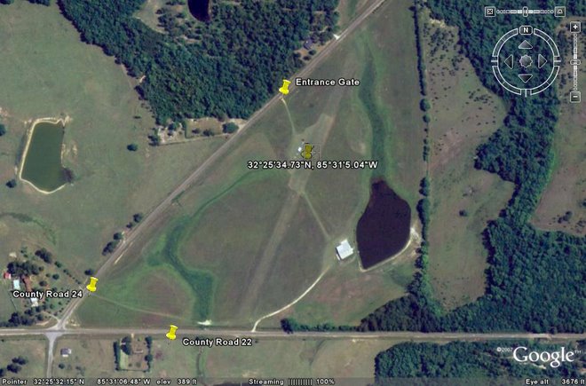
The field is conveniently located on the NORTH-EAST corner at the Intersection of Macon County Road 24 and Macon County Road 22 in Lee County, Alabama, about 15 miles south of Auburn / Opelika.
By Car:
Entrance is via Macon County Road 24 immediately north (about 700 yards) of Macon County Road 22 using the gate on the East Side.
The Gate is padlocked and members are required to close and lock the gate when they leave. GPS Location for gate: 32°25'38.15"N 85°31'7.39"W
Directions from Auburn, Alabama (Interstate 85, Exit 51):
Take AL 147 / US 29 (College Street) SOUTH past I-85, proceed to US Hyw 80.
There is NOT a ramp that goes from US 29 to US 80 EAST going south.
Immediately after passing US 80, make a U-Turn to US 29 NORTH to enter US 80 EAST Ramp.
Proceed on US 80 and Turn RIGHT on County Road 24.
You will drive past high tension wires with the 'markers' for aircraft
Just before County Road 22 (700 yards), look for Gate to enter Airfield on LEFT.
GPS Location for gate: 32°25'38.15"N 85°31'7.39"W
Directions from Phenix City, Alabama and Columbus, Georgia:
Take US 80 to County Road 24.
Turn LEFT onto County Road 22 and proceed to County Road 24.
Turn RIGHT on County Road 24 and look for gate immediately to RIGHT (700yards).
GPS Location for gate: 32°25'38.15"N 85°31'7.39"W
By Air:
From Robert G. Pitts Airport, Fly SSW 14 miles to:
32°25'34.73"N
85°31'5.04"W
Runway:
Approx. 1,900ft X 100ft Grass
Warning: Only 538ft in middle of runway is regularly mowed.
Elevation: 393ft
N-S Orientation
NO SERVICES ARE AVAILABLE AT THIS AIRFIELD
If you intend to fly in on a larger plane than a Cessna 182, it is recommended that a ground crew be sent ahead to survey the field. C-130s or larger craft require the land owner's permission before landing / takeoff unless an in-flight emergency has been declared.
